GBIF |
|
GBIF OGC Web Map Service
| Service health Now: |
|---|
- Interface
- Web Service, OGC Web Map Service 1.1.1
- Keywords
- WFS, WMS, GEOSERVER, Africa, Biodiversity, GBIF, mammal, http://www.eionet.europa.eu/gemet/concept/4982, bird, http://www.eionet.europa.eu/gemet/concept/912, reptile, http://www.eionet.europa.eu/gemet/concept/7124, amphibian, http://www.eionet.europa.eu/gemet/concept/387, insect, http://www.eionet.europa.eu/gemet/concept/4358, species, http://www.eionet.europa.eu/gemet/concept/7982, migratory species, http://eurogeoss.unizar.es/SBA/migratorySpecies, invasive species, http://eurogeoss.unizar.es/SBA/invasiveSpecies, http://eurogeoss.unizar.es/SBA/biodiversity, http://www.eionet.europa.eu/gemet/concept/827, http://www.eionet.europa.eu/gemet/concept/170
- Fees
- NONE
- Access constraints
- NONE
- Data provider
-
GBIF (unverified)
Contact information:
GBIFs
GBIF
Work:
Copenhagen, Denmark
Ads by Google
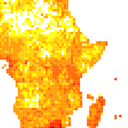
The OGC WMS of the Global Biodiversity Information Facility provides taxon occurrence data with wide taxonomic, geospatial and temporal coverage. Two sets of web services are available, one for an unfiltered view of the data, a second one that accepts a taxonomic filter. For each set of services, four layers were created, three layers of aggregated data and one layer for the full occurrence details. All four layers are associated with a zoom-based style descriptor and combined into a layer group. For each of the aggregation layers, a cluster table was created that merges all records for one grid cell into one cluster. Grid cell sizes range from 1 degree (111km) at the coarsest level to 0.01 degree (1.11km) and the finest level.
Available map layers (15)
country_Type (gbif:country_borders)
Generated from country_borders
country_Type (gbif:country_fill)
Generated from country_fill
country_Type (gbif:country_names)
Generated from country_names
pyramid is a Image pyramidal plugin (gbif:pyramid)
pyramid_1 is a Image pyramidal plugin (gbif:pyramid_1)
pyramid_2 is a Image pyramidal plugin (gbif:pyramid_2)
pyramid_3 is a Image pyramidal plugin (gbif:pyramid_3)
pyramid_4 is a Image pyramidal plugin (gbif:pyramid_4)
pyramid_5 is a Image pyramidal plugin (gbif:pyramid_5)
pyramid_6 is a Image pyramidal plugin (gbif:pyramid_6)
pyramid_7 is a Image pyramidal plugin (gbif:pyramid_7)
tabDensityLayer (gbif:tabDensityLayer)
bluemarble (bluemarble)
Layer-Group type layer: bluemarble
geobon_occurence (geobon_occurence)
Layer-Group type layer: geobon_occurence
geobon_tax_occurrence (geobon_tax_occurrence)
Layer-Group type layer: geobon_tax_occurrence
There are currently no notifications for the service, click the feed icon to subscribe.