Landcare Research New Zealand Limited |
|
Landcare Research NZ Land Cover Database
| Service health Now: |
|---|
- Interface
- Web Service, OGC Web Map Service 1.1.1
- Keywords
- Fees
- none
- Access constraints
- The spatial data hosted by this service is licensed under Creative Commons CC-BY license (http://creativecommons.org/licenses/by/3.0/nz/). The data itself is sourced from Landcare Research's own in-house datasets. Do not use this data for navigation purposes or any application where potentially lives might depend on.
- Data provider
-
Landcare Research New Zealand Limited (unverified)
Contact information:
David Medyckyj-Scott
Landcare Research New Zealand Limited
Postal:
Landcare Research, Private Bag 11052, Manawatu Mail Centre, 4442 Palmerston North, New ZealandEmail:
Phone: +64 6 353 4800
Ads by Google
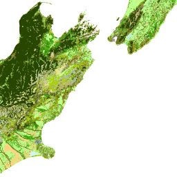
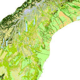
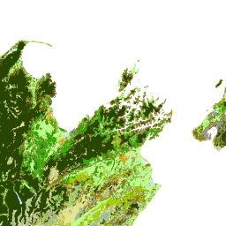
This is a W*S for LCDB, operated as part of the SCENZ-grid project. The spatial data hosted by this service is licensed under Creative Commons CC-BY license (http://creativecommons.org/licenses/by/3.0/nz/). The data is sourced from the LCDB (http://lris.scinfo.org.nz/#/layer/304-lcdb-v30-land-cover-database-version-3/). The LCDB is a thematic classification of land cover and land use classes. The current version LCDB v3 contains 33 classes designed to be compatible with earlier LCDB versions. The polygon features contain a code and boundary representing the land cover type at each of three periods; summer 1996/97, summer 2001/02, and summer 2008/09. The data set was designed to be compatible in scale and accuracy with Land Information New Zealand’s 1:50,000 topographic database. LCDB is intended to be used in areas such as state of environmental monitoring, forest and shrubland inventory, biodiversity assessment, trend analysis and infrastructure planning.. Do not use this data for navigation purposes or any application where potentially lives might depend on. This service runs a MapServer (http://mapserver.org/index.html) on top of a PostgreSQL / PostGIS database (http://www.postgresql.org/)(http://postgis.refractions.net/).
Available map layers (5)
Landcare Research NZ Land Cover Database (ext_lcdb)
This is a W*S for LCDB, operated as part of the SCENZ-grid project. The spatial data hosted by this service is licensed under Creative Commons CC-BY license (http://creativecommons.org/licenses/by/3.0/nz/). The data is sourced from the LCDB (http://lris.scinfo.org.nz/#/layer/304-lcdb-v30-land-cover-database-version-3/). The LCDB is a thematic classification of land cover and land use classes. The current version LCDB v3 contains 33 classes designed to be compatible with earlier LCDB versions. The polygon features contain a code and boundary representing the land cover type at each of three periods; summer 1996/97, summer 2001/02, and summer 2008/09. The data set was designed to be compatible in scale and accuracy with Land Information New Zealand’s 1:50,000 topographic database. LCDB is intended to be used in areas such as state of environmental monitoring, forest and shrubland inventory, biodiversity assessment, trend analysis and infrastructure planning.. Do not use this data for navigation purposes or any application where potentially lives might depend on. This service runs a MapServer (http://mapserver.org/index.html) on top of a PostgreSQL / PostGIS database (http://www.postgresql.org/)(http://postgis.refractions.net/).
Land Cover Database Version 1 - 1996 / 1997 (lcdb_lcdb1)
The LCDB is a thematic classification of land cover and land use classes. The current version LCDB v3 contains 33 classes designed to be compatible with earlier LCDB versions. The polygon features contain a code and boundary representing the land cover type at each of three periods; summer 1996/97, summer 2001/02, and summer 2008/09. The data set was designed to be compatible in scale and accuracy with Land Information New Zealand's 1:50,000 topographic database. This layer covers the summer 1996/1997 period.
Land Cover Database Version 2 - 2001 / 2002 (lcdb_lcdb2)
The LCDB is a thematic classification of land cover and land use classes. The current version LCDB v3 contains 33 classes designed to be compatible with earlier LCDB versions. The polygon features contain a code and boundary representing the land cover type at each of three periods; summer 1996/97, summer 2001/02, and summer 2008/09. The data set was designed to be compatible in scale and accuracy with Land Information New Zealand's 1:50,000 topographic database. This layer covers the summer 2001/2002 period.
Land Cover Database Version 3 - 2008 / 2009 (lcdb_lcdb3)
The LCDB is a thematic classification of land cover and land use classes. The current version LCDB v3 contains 33 classes designed to be compatible with earlier LCDB versions. The polygon features contain a code and boundary representing the land cover type at each of three periods; summer 1996/97, summer 2001/02, and summer 2008/09. The data set was designed to be compatible in scale and accuracy with Land Information New Zealand's 1:50,000 topographic database. This layer covers the summer 2008/2009 period.
Copyright Notice (copyright)
Landcare Research Copyright Notice
There are currently no notifications for the service, click the feed icon to subscribe.